Area size: 734 km2, 85 km distance to Tenerife
Capital: Santa Cruz de La Palma.
Approximately 90,000 inhabitants called "Palmeros".
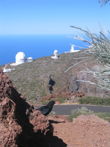
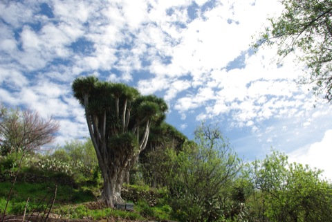 La Palma is also known as Isla Bonita (the beautiful island), enchanted with the unique and rich vegetation, especially the beautiful mountains suitable for hiking. It is one of the smaller western islands of the archipelago and shouldn't be confused with Las Palmas; the capital of Gran Canaria. It is geologically very young and the most active of all the volcanic islands. Its centre is the 8 km wide and 1500m deep Taburiente, which was declared a National Park in 1954. The steep cliffs of the caldera rise up to 2000m and the Roque de los Muchachos (2426m) tower over the highest mountain on the island. Here you'll find the international astronomical observatory, the Telescope is managed by the Instituto de Astrofisica de Canarias.
The ridge of the caldera continues in the Cumbre, a north-south running mountain range, turning part of the island into a humid and a dry east side/west side divide. The island has many different microclimates, so that the different climatic zones lie close together. Of particular note, the laurel forest of Los Tiloswhich in 1983 was denoted as bio-deveristy reserver by UNESCO. This is in stark contrast to the still volcanically active south, complete with its bizarre lava landscapes. The Teneguia volcano last erupted in 1971.
Hikes:
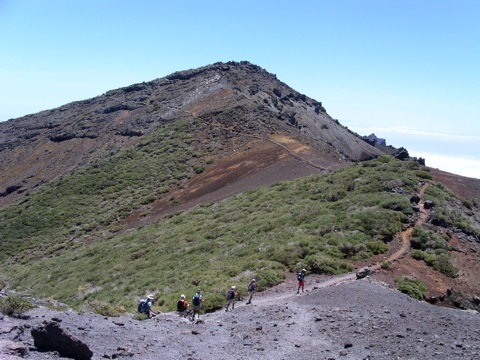 La Ruta de Los Vulcanes: The trail begins at the Refuge de El Pilar to an altitude of 1400m and leads to the plateau, la Deseada, at 1950m. The hike ends at Fuencaliente to 750m in a small village of Los Canarios, where you can sample excellent local wines. (Moderate, 6-7 hours, 500 m + -)
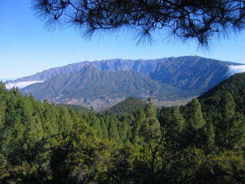 Caldera Taburiente: The walk starts at about 1000m and descends into the Las Angustias Gorge (Barranco), which is traversed by a brook which we pass through frequently. (Average, 6 hours, 650 m -) One of the most spectacular walks in La Palma.
Pico de Las Nieves – Roque de Los Muchachos: From Pico de las Nieves we walk to the Astrological Observatory (one of the most important in Europe) at Roque de los muchacho, an unforgettable experience ... (Average, 6 hours, 600 m + 150 m-)
Punta Gorda: Hike through a lush rural landscape with many trees and typical Canary Island dragon cave dwellings with the ocean always in view. (easy, 3 h, 200 m + -)
Los Tiles: Hike through the park through a dense laurel forest. A sub-tropical, prehistoric forest with giant ferns interspersed. Today, many of these types of laurel in southern Europe are extinct and are considered living "relics" which are under nature protection. (Medium, 5 h, 400 m + -)
Information and prices for a hikingweek please contact : Mail chris.laabmayr@yahoo.it
Capital: Santa Cruz de La Palma.
Approximately 90,000 inhabitants called "Palmeros".
 La Palma is also known as Isla Bonita (the beautiful island), enchanted with the unique and rich vegetation, especially the beautiful mountains suitable for hiking. It is one of the smaller western islands of the archipelago and shouldn't be confused with Las Palmas; the capital of Gran Canaria. It is geologically very young and the most active of all the volcanic islands. Its centre is the 8 km wide and 1500m deep Taburiente, which was declared a National Park in 1954. The steep cliffs of the caldera rise up to 2000m and the Roque de los Muchachos (2426m) tower over the highest mountain on the island. Here you'll find the international astronomical observatory, the Telescope is managed by the Instituto de Astrofisica de Canarias.
 The ridge of the caldera continues in the Cumbre, a north-south running mountain range, turning part of the island into a humid and a dry east side/west side divide. The island has many different microclimates, so that the different climatic zones lie close together. Of particular note, the laurel forest of Los Tiloswhich in 1983 was denoted as bio-deveristy reserver by UNESCO. This is in stark contrast to the still volcanically active south, complete with its bizarre lava landscapes. The Teneguia volcano last erupted in 1971.
Hikes:
 La Ruta de Los Vulcanes: The trail begins at the Refuge de El Pilar to an altitude of 1400m and leads to the plateau, la Deseada, at 1950m. The hike ends at Fuencaliente to 750m in a small village of Los Canarios, where you can sample excellent local wines. (Moderate, 6-7 hours, 500 m + -)
  Caldera Taburiente: The walk starts at about 1000m and descends into the Las Angustias Gorge (Barranco), which is traversed by a brook which we pass through frequently. (Average, 6 hours, 650 m -) One of the most spectacular walks in La Palma.
 Pico de Las Nieves – Roque de Los Muchachos: From Pico de las Nieves we walk to the Astrological Observatory (one of the most important in Europe) at Roque de los muchacho, an unforgettable experience ... (Average, 6 hours, 600 m + 150 m-)
Punta Gorda: Hike through a lush rural landscape with many trees and typical Canary Island dragon cave dwellings with the ocean always in view. (easy, 3 h, 200 m + -)
Los Tiles: Hike through the park through a dense laurel forest. A sub-tropical, prehistoric forest with giant ferns interspersed. Today, many of these types of laurel in southern Europe are extinct and are considered living "relics" which are under nature protection. (Medium, 5 h, 400 m + -)


Information and prices for a hikingweek please contact : Mail chris.laabmayr@yahoo.it
TREKKING EL HIERRO:
HIERRO: Area size: 268 km2 Capital: Valverde Population: 11,000 people
El Hierro, formerly known as "Ferro" (Iron), and Isla del Meridiano is the western most and smallest of the seven Canary Islands. Its share of the total land surface area of all the Canary Islands is 3.59 percent. El Hierro was nominated in 2000 as a Biosphere Reserve by UNESCO. By 2011, the island will become the first island of its size, powered exclusively by renewable energy.
Highest Mountain: El Paso 1500 m.

The Canaries seem in ancient times, a a distant concept, life was far away and paradisiacal. Maybe it was the Phoenicians who visited these islands. There are many myths and legends but hard evidence is poor at best. The Greek poet Homer in his odyssey around the 8th Century BC Later Hesiod sings of the Isles on the edge of the world, but whether or not this was talking about the Canary Islands is not clearly defined.
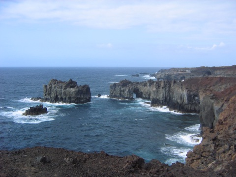 When the first settlers arrived, and where they came from, is not clearly understood. There were immigrants who fled famine in front of the expanding Sahara and possibly the devestation of their homeland by the Romans. The only certain thing is, the further north they started with seaworthy boats, the more likely they met with the Atlantic currents flowing to the Canaries. The Spanish conquerors arrived in the Canary Islands to an intact stone-age culture. The last phase of the Stone Age in the Canary Islands goes back only about 500 to 600 years.
Linguists think that settlers from northern West Africa must have come to the islands. There are similarities with the Berbers of North Africa and Libya. The settlement of El Hierro took place after the 5th Century BC instead. Herreños the people who called themselves Bimbaches, probably must have found it hard to walk on the steep coastal land. But it was probably even harder to go with the simple boats against the current back to land. Connections to the neighboring islands must have been sparse. But a legend says that a woman from La Gomera is said to have taught the Herreños to make fire.
The current name Hierro has nothing to do with the Spanish word for iron, which occurs at all on the island. Rather, the natives called their island Esero or Ero, which as much as strong, means firm or hard.
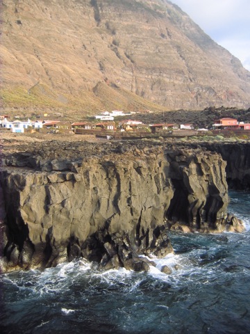 On his second trip, Columbus contributed to La Gomera and El Hierro, fresh water and food supplies. He also wanted to wait for a favorable wind, which should allow its fleet of 17 ships to move rapidly westward. After 19 days on El Hierro, on 3 October 1493, a strong trade wind finally blew from the Bahía de Naos in the New World.
FAUNA: In addition to various species of frogs, lizards are particularly common on El Hierro, like the endemic geckos Tarentola boettgerio. The most common species of lizards (Lagartos) is the small Canary Island lizard (Gallotia Caesaris) up to 35 cm in length. Often one can see the blind Canary skink (Chalcides viridanus). There are no snakes in the Canary Islands. The coastal waters are well populated with sea turtles (Caretta), the largest reptile in the archipelago.
Hierro is known for a large prehistoric lizard, Gallotia the simonyi simonyi, or Spanish: Lagarto gigante. It is certain that they are indigenous to the island since time immemorial. The species retreated to northern El Golfo valley, back to the Roques de Salmor, where towards the end of the 18th Century were rediscovered.
FLORA: Laurel forest, gale tree ferns, juniper, and many endemic species (see book: Plants leader Canary Islands,by Thomas K. Mueller)
The interior of the island, north of San Andrés up to about 1,000m above sea level. There is another landmark of the island, the Garoé (arbol santo), the sacred tree of the natives. A small information centre offers information about the history and significance of this tree, which was used by the natives as a water dispenser and revered. The recording of the sacred tree at the crest of the island illustrates its historical significance.
WALKS IN EL HIERRO
La Sabinosa – Hermita de Los Reyes
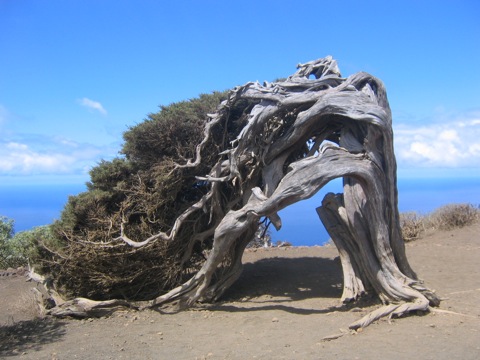
From the small village of Sabinosa we wander through vineyards and orchards to the Mirador de Bosco (a view point), with magnificent views of El Golfo. We continue towards El Sabinar and enter the nature reserve Mencafete, where we see the Juniperus turbinata, a protected plants which is sculpted by the prevailing winds into fascinating shapes. Our goal is the Hermit de Los Reyes. (Moderate, 4-5 hours, 600 m +)
La Frontera – Mirador de Jinama – Mirador de La Peña
From a small church in Frontera, we climb up to the Mirador de Jinama (1200m) (a view point). We walk through a pasture where cows and goats graze. Slowly we climb down to Hermit de la Pena (650m). Visit the Museum of the giant lizards of Salmor (Gallotia Simonyi). After the hike, you can take a swim in natural pools * (Moderate, 4-5 hours, · 550m - 900m +).

Masca Gorge walk: We start from the romantic old village and go through a really impressive gorge. after 3 hours we arrive to the natural, wild bay of Masca. The clear water of the atlantic invites us to take a swim or we just relax on the beach. A boat will bring us back to the habour of Los Gigantes. With luck we can sometimes watch the dolphins which inhabit this area near the big cliffs called “Los Gigantes". (medium grade, 3 hours. Its possible to walk it down or up: descent/ascent 650 m)
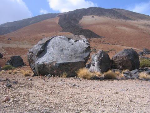 Mount Teide - Volcano Walking tour: We start from 2300 m on a large footpath in the middle of the big caldera "Cañada del Teide". We pass the famous "huevos del Teide" - big lava deposits - and arrive near the top of Montaña Blanca. Now we follow a small and steep footpath which brings us up to the refuge "Altavista"(3260m). After a short stop we continue on a well prepared footpath through an amazing lava landscape till we arrive to the cablecar station. Now we have to show our permits from the park-office to the rangers and than we tackle the last 150 m till we arrive on the summit of Spain's highest peak! We have an impressive view of the crater and distant views of Gomera, La Palma, Gran Canaria and over Tenerife. Descent is by cable car. (difficult grade, 5 hours, 1400 m ascent)
 Vilaflor – Lunar landscape: We begin and end out walking tour in this old mountain village. The footpath brings us first to a typical rural area with cultivated terraces and almond and fig trees. After half an hour we walk through a wonderfully aromatic pinetree forest. On arrival, we rest at the strange rock sculptures called "Paesaje Lunar". (medium grade, hours, ascent and descent 450 m )
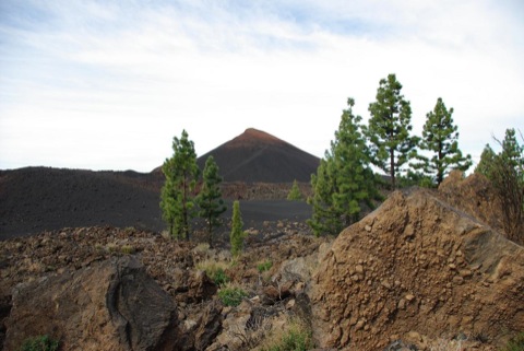 El Cinyero Circel - walking tour: A very special lava landscape let us relive the last eruption of Tenerife in 1909 when Volcana El Cinyero (1400 m high) caused disconcerted locals or ten days. The picuresque contrast of black lavafields and green pinetrees present very special scenery . (Easy grade , 3 hours, Ascent and descent 200 m ).
 El Portillo – Montana Blanca:
 Mount Teide - Volcano Walking tour: We start from 2300 m on a large footpath in the middle of the big caldera "Cañada del Teide". We pass the famous "huevos del Teide" - big lava deposits - and arrive near the top of Montaña Blanca. Now we follow a small and steep footpath which brings us up to the refuge "Altavista"(3260m). After a short stop we continue on a well prepared footpath through an amazing lava landscape till we arrive to the cablecar station. Now we have to show our permits from the park-office to the rangers and than we tackle the last 150 m till we arrive on the summit of Spain's highest peak! We have an impressive view of the crater and distant views of Gomera, La Palma, Gran Canaria and over Tenerife. Descent is by cable car. (difficult grade, 5 hours, 1400 m ascent)
Guajara – Vilaflor:We start from "Parador National" in the Cañada del Teide (2100 m)and walk a very panoramic footpath just till arriving under the big basalt rockcliffs of Guajara - 3th highest peak of the National Park 2715 m. After a rest with marvelous views we continue our walk down to the pine forest, crossing volcanic landscapes of special beauty. After 4 hours we reach the "Paesaje Lunar". A quick rest and then we follow the foothpath through forests till Vilaflor (1400m). Very beautiful panoramic walk. (difficult, 6-7 hours. Ascent 600m, decent 1200m).
 Vilaflor – Lunar landscape: We begin and end out walking tour in this old mountain village. The footpath brings us first to a typical rural area with cultivated terraces and almond and fig trees. After half an hour we walk through a wonderfully aromatic pinetree forest. On arrival, we rest at the strange rock sculptures called "Paesaje Lunar". (medium grade, hours, ascent and descent 450 m )
 El Cinyero Circel - walking tour: A very special lava landscape let us relive the last eruption of Tenerife in 1909 when Volcana El Cinyero (1400 m high) caused disconcerted locals or ten days. The picuresque contrast of black lavafields and green pinetrees present very special scenery . (Easy grade , 3 hours, Ascent and descent 200 m ).
 El Portillo – Montana Blanca:
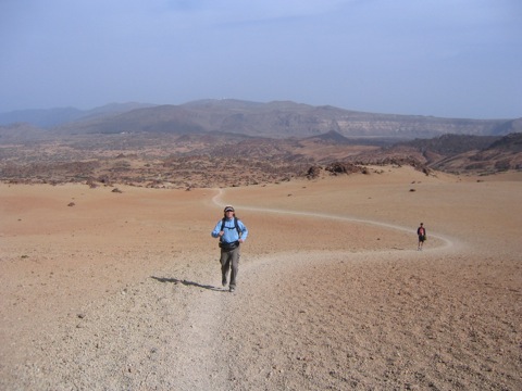
After visiting the interesting Museum in El Portillo, our footpath brings us in a fantastic Western landscape. Always looking towards Teide's summit in front of us we walk till arriving at the famous volcanic deposits called: ”Huevos del Teide" (teide-eggs 2700m). We reach the Montaña Blanca top and have a great view over "Las Cañadas" an enormous caldera. During our descent we will see a lot of obsidians and pomice-stones (easy grade, 4 hours , ascent 480m, descent 200m).
Silos – Erjos: We start in Garachico on the north coast and traverse the different levels of vegetation. First past the villas with banana and fruit plantations, we arrive at the typical thick-leaf plant and cactus vegetation. Next we reach the low Fayal Brezal scrub forest and finally reach the dense laurel forest. Botanically one of the most interesting areas. In the small mountain village Erjos we are finally at the finish. (Medium., 5 hrs 800m +, and vice versa
Buenavista – El Bailadero: At Buena Vista we start on a rocky trail with a steep rise in altitude. The steep climb through the high pastures affords stunning views of the North Coast. We cross the pasture at Teno Alto and reach the small hamlet of El Bailadero, famous for its excellent goat's cheese, which of course we can try with a glass of wine. (Demanding, 4 hours, 600m +)
El Bailadero – Baracan: From the small hamlet of Teno Alto, we hike on the mountain ridge, with magnificent views over the village of El Palmar and the island of La Gomera in the blue Atlantic. (Medium, 3 h + 200 m).
Garachico – San Juan de ReparoWe follow a rapidly rising zig zag path with stunning views over the town of Garachico and the north coast, arriving in the town of San Juan. (Mild, 2.5 hrs 500M +).
El Cinyero This hike takes us through the landscape of the last volcanic eruption on Tenerife, "El Cinyero" in December 1909. The contrast of black lava and green pine trees is particularly charming. The lava and ash dumps are impressive. (Easy, 3 hours, 200 + -).
Las Fuentes: This hike takes you through the Canary Island's rural countryside with old houses, man-made terraces and the typical caves. (Easy, 3 hrs, 250 + / -)
Las Portelas – Santiago del Teide:Part of a tightrope walk with magnificent views and the typical meteorological divide between north and south sides. Heath and laurel forests, alternating with the Crassulaceae family. Finally, a somewhat steeper descent to Santiago del Teide, where we visit an old country house. (Medium, 3 hours, 300 + / -)
Montana Samara – Montana Reverenda: The trail going through the lava fields is of great interest and we are already in the high mountain area with views of Teide and Pico Viejo. (light, 2.5 hours, 200 + / -)
Bejia – Batanes:This is a charming circuitous walk in the Anaga mountains. The journey to our starting point is through the dense forest Mercedes. The trail begins in the hamlet called Bejia and leads ancient terraces that are still partly cultivated up to present day. we carry on through some dark water-bearing tunnels, so take a headlamp! (Average, 4 hours, 250 meters + / -)
Chamorga – Circel walking tour: This trail in the eastern part of Tenerife is certainly one of the most beautiful, taking us to the Chamorga lighthouse, pointing the way for the ships at night. The cliffs drop away below us; wild and enchanting. (average, 4 hours, 400 meters + / -)
Cruz del Carmen – Punta de Hidalgo: From a laurel forest, we descend to Cinamada and on to Punta del Hidalgo. The differences in the climate zones are starkly apparent, each with their repsective typical flora. A great experience. (Average, 5 hours, 700 -)
Punta de Hidalgo – Cinamada:From the coast of Punta de Hidalgo We continually climb up a path carved into the rock that leads through cactus and euphorbia. The ancient volcanic rocks stratified in their red and brown hues stand out from the blue of the Atlantic. There are always breathtaking views of the sea and the surrounding rocky valleys. Arriving at the old cave village Cinamada, we return to the bar "La Cueva". (medium 3 h, 600 m +)
La Caldera - Los Organos: The trail begins in the north of the caldera, a beautiful picnic area with barbeques. We walk through a pine forest up to the Organos; a basalt rock formations shaped like organ pipes. The trail ends back at the starting point. Occasionally the fog creep up from below making the the landscape very mysterious. (Intermediate, 5 hr, 400 m + / -)
Las Canadas - Pico Viejo: This is a Climb to Tenerife's second highest volcano (3150m), through one of the most impressive lava landscapes, this arduous path leads up to 800 m wide crater diameter. (very challenging, 4 hrs, 1200m + / ??- or by cable car to the valley) and many more.
WALIKING IN LA GOMERA, LA PALMA AND EL HIERRO
The smaller neighbouring islands of Tenerife are easy to reach by boat. Los Cristianos port has daily ferries by Fred Ohlsen and Navieras Armas.Tickets are available right on the harbour. The islands are especially beautiful for hiking, because they are still very primitive. Old Canarian traditions or clearly visible in some of the smaller villages. We therefore recommend a few days to schedule a visit. It is ideal after a week's hiking in Tenerife to spend two to three day visiting La Gomera. During a two-week stay, we recommend a four-island tour. On the small islands, we recommend smaller hotels and guesthouses with typical Canarian fare.


 +34 (0) 634 04 80 57